Hi Mountain Trail in Arroyo Grande
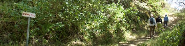
Hi Mountain Trail is located in the Santa Lucia Mountains east of Lopez Lake. The San Luis Obispo County-run trail is quite different from the area's coastal hikes and covers a variety of environments in a short distance. Start with a nice-and-easy stream-side trail through a dense woodland. Bust up a ridge and suddenly you're in a grassy landscape with panoramic views. ...Read more.
Distance: 3.25 miles · Elevation change: 575 feet
By: Published: June 8, 2015 Last updated: December 5, 2025
Bluff Trail in Fiscalini Ranch Preserve
Fiscalini Ranch Preserve (previously called East West Ranch) is a 434-acre park right in the middle of Cambria, a coastal town at the north end of San Luis Obispo County. Bordered by neighborhoods to the north and south, the preserve provides public access to a mile of beautiful coastline spared from development except for trails with boardwalks, bridges, and whimsical benches made out of driftwood. ...Read more.
Distance: 1.9 miles · Elevation change: 50 feet
By: Published: June 5, 2015 Last updated: December 5, 2025
Old Prospector Trail Loop in Irish Hills Natural Reserve in San Luis Obispo
Today the Irish Hills are like a gold mine for hikers, but the small mountain range in San Luis Obispo historically hosted several mines for chromium and mercury. The ruins of one of these mines can be visited on Old Prospector Trail, which opened in 2015 to join the growing group of trails in Irish Hills Natural Reserve. This hikers-only single track starts in Froom Canyon and is 0. ...Read more.
Tagged with · Free Trails · Irish Hills · Mines · Ruins
Distance: 4.4 miles · Elevation change: 650 feet
By: Published: March 18, 2015 Last updated: April 9, 2026
Trails in Montaña de Oro State Park
Montaña de Oro State Park has dramatic ocean bluffs and summits with sweeping views. The park covers over 8,000 acres and has 7 miles of undeveloped coastline, making it a rare treasure on the California Coast. One road leads into the park, entering from the town of Los Osos to the north, which is just west of the city of San Luis Obispo. Visitors can stay overnight at a 50-site campground at the center of the park. ...Read more.
By: Published: February 9, 2015 Last updated: April 8, 2026
Cuesta Ridge Botanical Area via West Cuesta Ridge Road in Los Padres National Forest
Discover a tucked-away oasis of Sargent cypress straddling a ridge in the Santa Lucia Mountains north of San Luis Obispo. The evergreens are accompanied by coastal views that could have you imagining you're somewhere farther north in California. The hike to Cuesta Ridge Botanical Special Interest Area is 6 miles round trip up a partially paved road with 950 feet of elevation change. ...Read more.
Distance: 6 miles · Elevation change: 950 feet
By: Published: February 7, 2015 Last updated: December 5, 2025
Inspiration Point via Tunnel Trail and Jesusita Trail from Tunnel Road in Santa Barbara
Located in the Santa Ynez Mountains, 1,800-feet above the Santa Barbara Coast, Inspiration Point attracts hikers with panoramic views over city and sea. Two routes lead to this picturesque perch. If you want to make a day of it, you can approach the viewpoint from the west on a moderate 7.55-mile round trip trek up Jesusita Trail to Inspiration Point from San Roque Road. ...Read more.
Distance: 3.75 miles · Elevation change: 825 feet
By: Published: January 28, 2015 Last updated: April 9, 2026
Coon Creek Trail in Montaña de Oro State Park
Coon Creek Trail explores a coastal canyon at the south end of Montaña de Oro State Park. The trail heads inland for 2.5 miles to a pleasant grove of Monterey cypress at the site of an old homestead that has since disappeared. Take a break in the shade of the cypress trees before turning around for a 5-mile round trip hike with 250 feet of elevation gain. ...Read more.
Distance: 5 miles · Elevation change: 250 feet
By: Published: September 29, 2014 Last updated: April 9, 2026
Balconies Cave in Pinnacles National Park
Pinnacles National Park preserves some of California's oddest landscapes with out-of-place rock spires and boulder-filled gorges with talus caves just waiting to be explored. Grab your headlamp and head to the west side of Pinnacles National Park for a trek into Balconies Cave. This fun 2-mile out and back hike or 2.4-mile lollipop loop hike crosses a playground of volcanic rock formations and journeys through the dark, twisting passages of Balconies Cave. ...Read more.
Distance: 2 miles · Elevation change: 200 feet
By: Published: July 31, 2014 Last updated: December 17, 2025
High Peaks – Balconies Cave Loop in Pinnacles National Park
Pinnacles National Park is a spectacular place to hike with a High Peaks area covered in rock spires and equally impressive boulder-filled gorges with talus caves. See both the High Peaks and Balconies Cave on a great 9-mile loop through diverse Pinnacles landscapes. Starting in the east, this clockwise loop ascends 1,575 feet to a thrilling crossing of the High Peaks, then descends Juniper Canyon to the west side of the park, and passes through Balconies Cave to close the hike with an easy walk back on Old Pinnacles Trail. ...Read more.
Distance: 9 miles · Elevation change: 1575 feet
By: Published: July 30, 2014 Last updated: April 9, 2026
Pinnacles Campground in Pinnacles National Park
Pinnacles National Park has spectacular boulder-strewn mountains and gorges filled with talus caves. The park is a playground for hikers and climbers. For campers, there is Pinnacles Campground, a 149-site campground set within an oak woodland on the east side of the park. While the campground isn't in the middle of all the awesome rock formations, the park's fun is close at hand. ...Read more.
Tagged with · National Parks · Paicines · Tent Camping
By: Published: July 28, 2014 Last updated: April 26, 2026