Tequepis Trail in the Los Padres National Forest
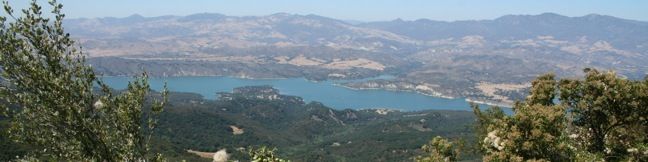
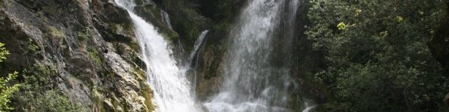
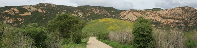
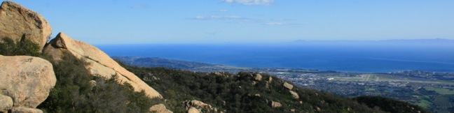
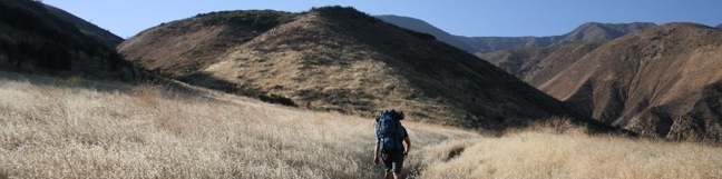
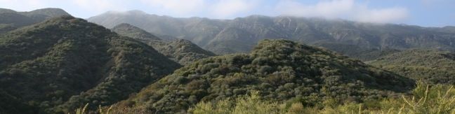
Tequepis Trail begins near the shores of Lake Cachuma and ascends the north side of the Santa Ynez Mountains behind Santa Barbara. The trail up offers views of the lake and valley, and there are broader ocean views from the top. This is an invigorating 8.4-mile round trip hike with 2,300 feet of elevation gain. To reach Tequepis Trail, start at the free parking lot at the entrance of Circle V Camp. ...Read more.
Distance: 8.4 miles · Elevation change: 2300 feet
By: Published: November 16, 2010 Last updated: April 9, 2026
Salmon Creek Falls in Los Padres National Forest
Salmon Creek Trail is a popular track with backpackers venturing deep into the Silver Peak Wilderness in the Monterey District of Los Padres National Forest, but you only need to hike a quarter mile round trip from Highway One to see a beautiful 120-foot waterfall. Unlike the trail overlooking beautiful McWay Falls farther up the Big Sur Coast, this hike brings you up close and person with a powerful cascade pouring down the Santa Lucia Mountains. ...Read more.
Distance: 0.25 miles · Elevation change: 60 feet
By: Published: May 28, 2010 Last updated: December 9, 2025
Jade Cove and Plaskett Rock Point in Los Padres National Forest (Big Sur)
Along the bluffs of the Big Sur Coast protected by Los Padres National Forest is a scenic and easy ocean-view hike. Jade Cove and Plaskett Rock Point are just south of Plaskett Creek Campground on the west side of Highway One. Visited together, they form a 1.5-mile hike. This hike has two trailheads. Both are unmarked a somewhat difficult to spot. From Plaskett Creek Campground drive a quarter mile south and scan the west side of the road for the Plaskett Rock Point trailhead. ...Read more.
Distance: 1.5 miles · Elevation change: 150 feet
By: Published: May 28, 2010 Last updated: April 9, 2026
Partington Cove in Julia Pfeiffer Burns State Park
A great way to explore the dramatic waterfront on the Big Sur coast is to take a hike down the action-packed Partington Cove Trail. Partington Cove is part of Julia Pfeiffer Burns State Park begins from Highway One, just north of McWay Falls. Partington Cove Trail The 1.5-mile hike to Partington Cove begins at the top of a gated fire road on the west side of Highway One and descends toward the coast to a junction at an information kiosk 0. ...Read more.
Distance: 1.5 miles · Elevation change: 270 feet
By: Published: May 27, 2010 Last updated: April 8, 2026
McWay Falls in Julia Pfeiffer Burns State Park
The overlook trail for McWay Falls is a must-stop for anyone taking the scenic drive up Highway One along the Big Sur Coast. The waterfall is stunning, dropping some 80 feet onto a pristine beach in an enchanting cove. It is a short 0.6-mile round trip hike to a viewpoint for McWay Falls, which can be reached directly from Highway One or from parking areas withing Julia Pfieffer Burns State Park. ...Read more.
Distance: 0.6 miles · Elevation change: 50 feet
By: Published: May 26, 2010 Last updated: April 8, 2026
Gaviota Wind Caves in Gaviota State Park
The Gaviota Wind Caves are a sandstone formation located a mile from the Pacific Ocean in the Santa Ynez Mountains west of Santa Barbara. The hike to the wind-swept caves is 2.5 miles round trip with 600 feet of elevation gain. One good thing about the Gaviota Wild Caves is that they are easy to get to from the 101. In fact, the wind caves can be seen from the freeway. ...Read more.
Distance: 2.5 miles · Elevation change: 600 feet
By: Published: March 15, 2010 Last updated: December 5, 2025
Lizard’s Mouth in Los Padres National Forest
Lizard's Mouth is a mountain top rock formation overlooking Santa Barbara. Wind-carved pockets on the underside of this sandstone outcropping give the rock a resemblance to a frog or lizard's mouth. The short hike to Lizard's Mouth offers sensational views and is a quick excursion for anyone traveling the 154 between Santa Barbara and Lake Cachuma or Los Olivos. ...Read more.
Distance: 0.5 miles · Elevation change: 25 feet
By: Published: March 14, 2010 Last updated: April 8, 2026
Tangerine Falls in Los Padres National Forest
After a spring rain, the 100-foot Tangerine Falls blooms into the most beautiful waterfall in Santa Barbara. The seasonal waterfall dries out for much of the year, but is spectacular at the peak of the rainy season. The 2.5-mile excursion to Tangerine Falls has 875 feet of elevation gain and everything a hiker could want — a soothing creek, plenty of shade, ocean views, and even a bit of off-trail rock hopping and scrambling (not to mention an exceptional waterfall). ...Read more.
Distance: 2.5 miles · Elevation change: 875 feet
By: Published: March 12, 2010 Last updated: December 5, 2025
Sespe Creek to Willett Hot Springs in Los Padres National Forest
Located just north of Ojai, Sespe Wilderness is the largest wilderness area within Los Padres National Forest, occupying 342 square miles. Sespe Creek cuts through this land and the adjacent trail offers great views of a wide valley and scenic creek. The trail starts from Piedra Blanca trailhead near Rose Valley Falls and leaves the dense green of the bays, oaks, and chaparral for grassland plains that feel surprisingly southwestern. ...Read more.
Distance: 19 miles · Elevation change: 500 feet
By: Published: February 26, 2010 Last updated: December 5, 2025
Wheeler Gorge Campground and Nature Trail in Los Padres National Forest
Wheeler Gorge offers a campground and a nature trail. If you are planning an overnight visit to the Los Padres near Ojai, keep Wheeler Gorge campground as an option. When the free campgrounds fill up with weekend fishermen, Wheeler Gorge is an attractive alternative. Single sites go for $25 a night (and $10 for additional vehicles). Double sites are available for $50 per night (all prices as of 2018). ...Read more.
Distance: 0.7 miles · Elevation change: 100 feet
By: Published: February 25, 2010 Last updated: April 6, 2026