Hikes in Colorado National Monument

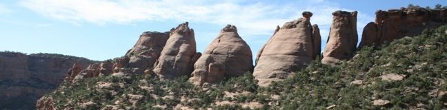
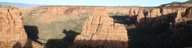
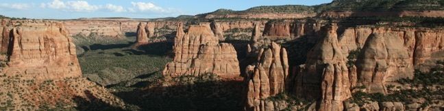
Colorado National Monument protects 32 square miles of wilderness near Grand Junction, Colorado. Monument Canyon is the reason for this area's preservation, running north to south through the park and housing sandstone formations that have inspired names like Window Rock, Praying Hands, and Kissing Couple. The canyon's most notable feature is Independence Monument, a 450-foot spire at the heart of Monument Canyon. ... Read more.
Coke Ovens Trail in Colorado National Monument
Coke Oven's Trail shares a trailhead with Monument Canyon Trail and the collection of rock domes can be visited as their own destination or as a side attraction on a longer trek into Monument Canyon. The hike to Coke Ovens is one-mile round trip with 180 feet of elevation loss. From the turnout along Rim Rock Drive, begin hiking east into the canyon. ...Read more.
Tagged with · Desert Canyons · Fruita · Grand Junction
Distance: 1 mile · Elevation change: 180 feet
By: Published: September 6, 2010 Last updated: April 6, 2026
Otto’s Trail in Colorado National Monument
Otto's Trail is one of the shorter hikes along Rim Rock Drive in Colorado National Monument. Like Window Rock Trail, this 0.75-mile stroll descends gradually to a cliff overlooking Monument Canyon. The view showcases Independence Monument, the tallest freestanding formation in the canyon, and a point of fascination for visitors dating back to the first park supervisor, John Otto, for whom this trail is named. ...Read more.
Tagged with · Desert Canyons · Fruita · Grand Junction
Distance: 0.75 miles · Elevation change: 85 feet
By: Published: September 3, 2010 Last updated: April 6, 2026
Alcove Nature Trail in Colorado National Monument
Across the road from the park visitor center (and Canyon Rim Trail) is Alcove Nature Trail. This track is set back from the canyon rim, which limits views of the great landscape. What this trail offers instead is an informative hike with numbered markers that coincide with entries in a guide booklet. The entries describe plants and animals in the park as well as the geological history. ...Read more.
Distance: 1 mile · Elevation change: 175 feet
By: Published: September 2, 2010 Last updated: April 8, 2026
Canyon Rim Trail in Colorado National Monument
For a view of Praying Hands, Independence Monument, and the other statuesque monoliths in Monument Canyon, take a stroll along Canyon Rim Trail. The track crosses the canyon rim between Saddlehorn Visitor Center and Book Cliff View, and is a great way to begin your visit of Colorado National Monument. The trail is half a mile one-way or one mile round trip. ...Read more.
Tagged with · Desert Canyons · Fruita · Grand Junction
Distance: 1 mile · Elevation change: 100 feet
By: Published: September 2, 2010 Last updated: April 6, 2026
Window Rock Trail in Colorado National Monument
Window Rock Trail begins next to Bookcliff Shelter, not far from Saddlehorn Campground. The trail looks south into Monument Canyon and north over the cities below. This 1/3-mile round trip hike ends at a distinct point at the north end of the western wall of Monument Canyon where a natural window pierces the top of the cliff. Window Rock Window Rock Trail is wide and easy to follow, descending gradually about 60 vertical feet through a forest of Pinyon pines and Utah junipers. ...Read more.
Tagged with · Desert Canyons · Fruita · Grand Junction
Distance: 0.35 miles · Elevation change: 60 feet
By: Published: September 2, 2010 Last updated: April 6, 2026