Santa Ynez Falls
in the Santa Monica Mountains

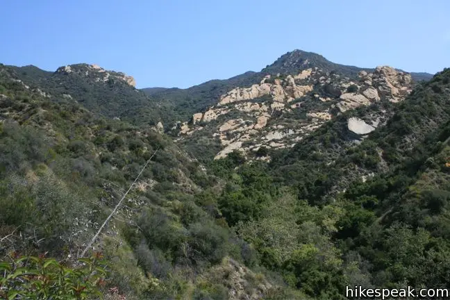
Santa Ynez Falls Trail follows a shaded creek to a gorge containing a short waterfall. This 2.5-mile hike is a popular family outing because it is fairly level (just 250 feet of elevation change) and interesting enough to hold a child’s attention for the duration.
- Santa Ynez Falls is one of the Los Angeles waterfall hikes.
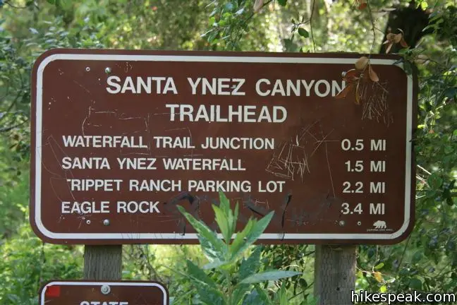
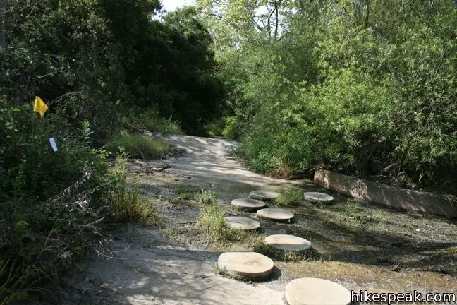
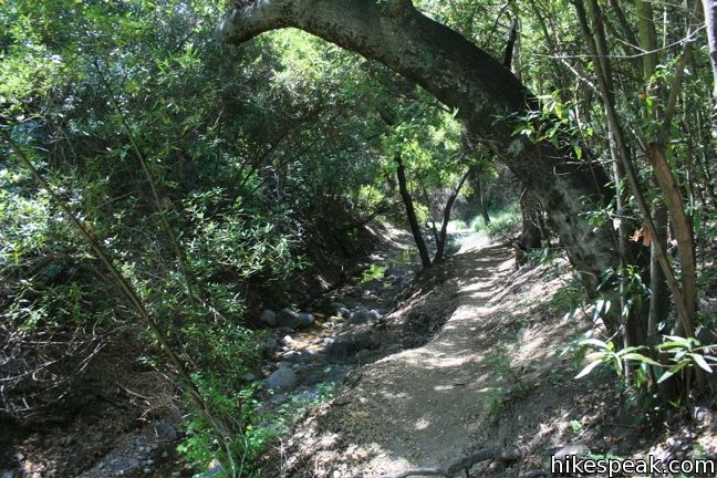
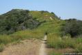
The hike begins from a free trailhead into Topanga State Park in the Pacific Palisades. Descend from the gate on Vereda de La Montura in the Pacific Palisades and begin along the single-track trail. Use the concrete stepping stones to cross the water flowing down a runoff channel, and leave the urban world behind.
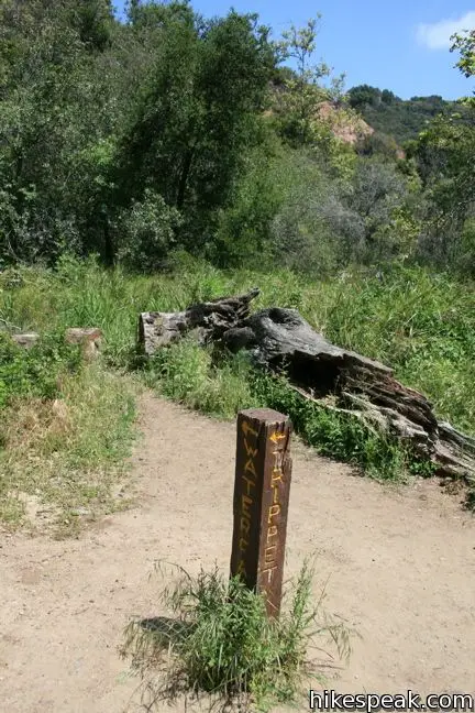
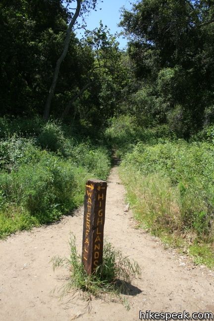
Cross through a dense forest to the first of many creek crossings. Rock hop the babbling waters and follow the trail to a junction 0.6 miles from the start. The trail to the left heads to Trippet Ranch and Eagle Rock, while the trail to the right continues toward Santa Ynez Waterfall. Take this single track, which drops down to the creek, crosses it, and turn left, heading upstream.
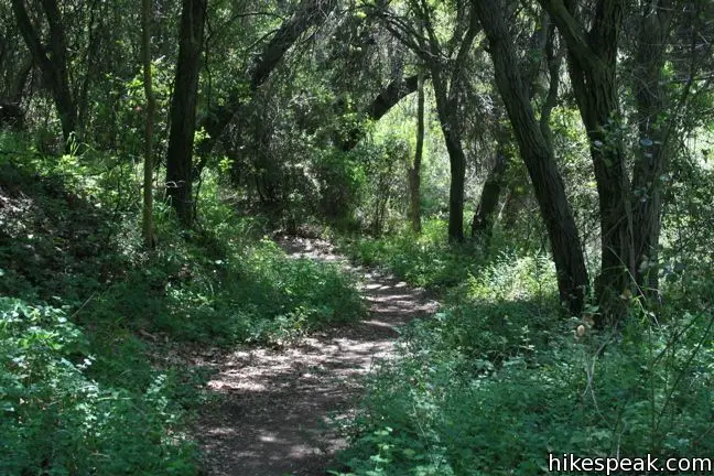
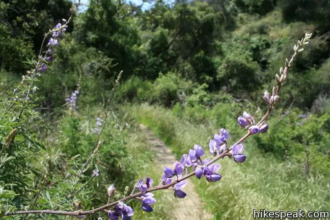
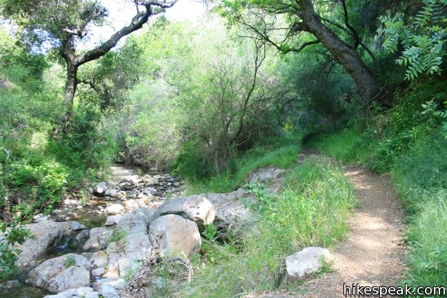
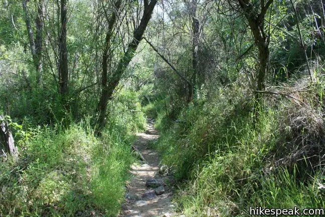
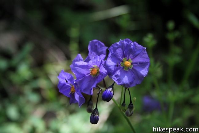
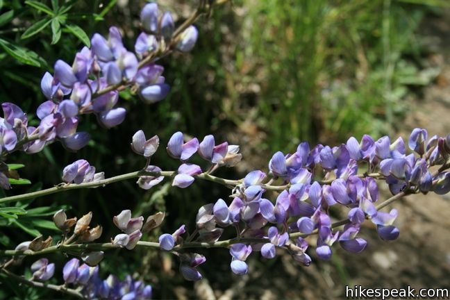
After a hundred yards, if you look to the opposite side of the creek, you’ll see a stone chimney left behind from an old cabin in the canyon. Stroll along the calming creek through a quiet forest of oaks, sycamores, and bays. Breathe deep and listen to the trickling water. That relaxing fragrance comes from the leaves of the California bays, that also provide a shady canopy along the cool canyon. In the spring, wildflowers like lupines and purple nightshade bloom in small meadows and pockets of sunlight.
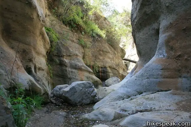
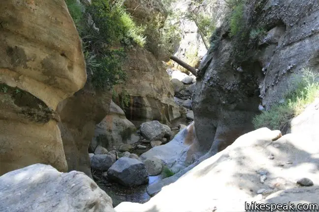
The trail remains alongside the creek, crossing it at points. Staying on course can get a bit tricky as there are footpaths breaking off at several points, trying to lure you away from the trail. When in doubt, stay with the water. As long as you don’t stray too far from the creek, you will end up at the right place.
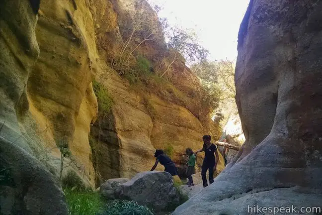
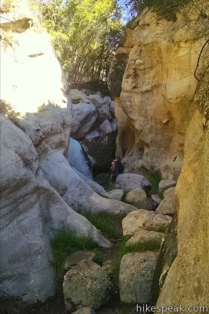
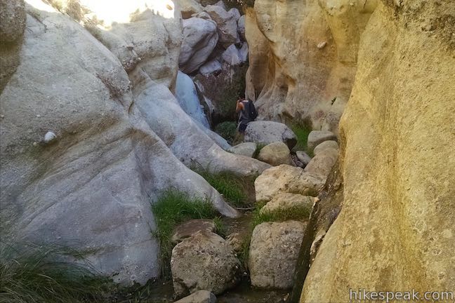
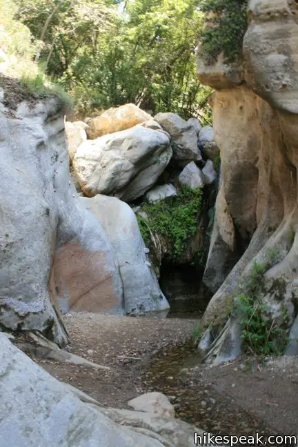
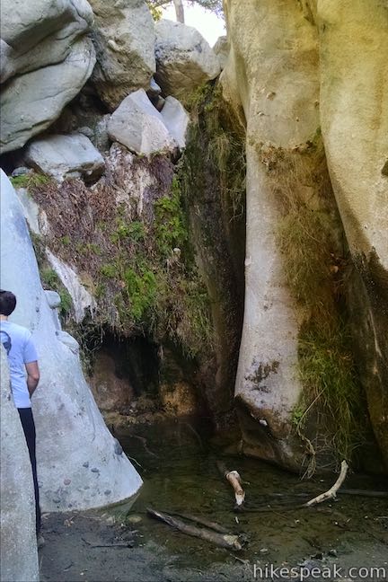
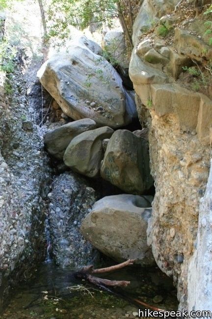
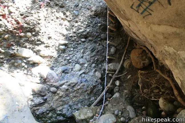
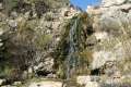
When the canyon walls close, you are nearing the waterfall. As the trail ascends the right bank of the canyon (leading to several dead ends), jump the trail and begin rock hoping up the creek. As long as the water is low, this should not be a problem. If the water level is high, head up the wall of the canyon and drop back down. The narrows present one obstacle that requires a bit of dexterous climbing. The water pours over a cluster of rocks in the center of the gorge and there is no easy way to continue upstream. Either cross the ledge to the right, passing below a low overhang that could be difficult for taller hikers, or hop across the creek and hoist yourself up the conglomerate rock on the left side of the creek. Both routes are feasible for agile hikers.
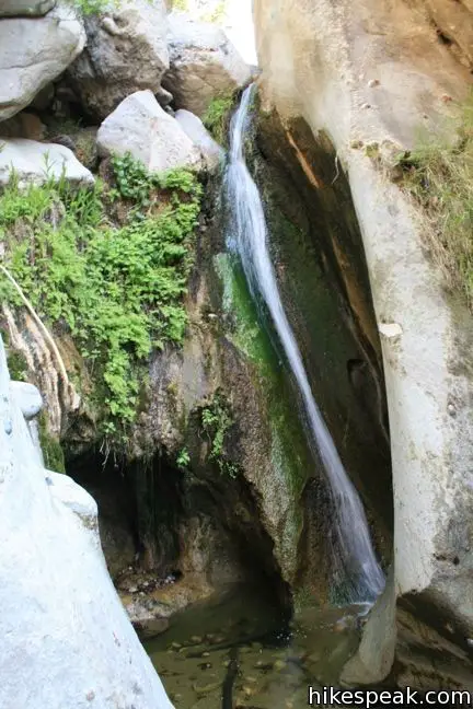
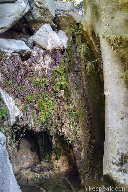
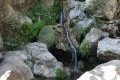
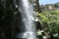
Above the obstacle, rock hop and climb a few hundred feet farther to Santa Ynez Falls. The 18-foot waterfall looks diminutive outside of the rainy season, but the enjoyable hike to the cascade makes up for it. Maidenhair ferns drape down the rock alongside the falls, which spills into a small shadowy grotto.
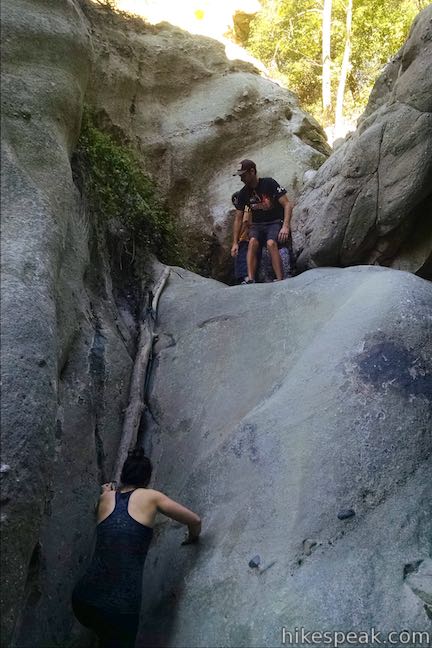
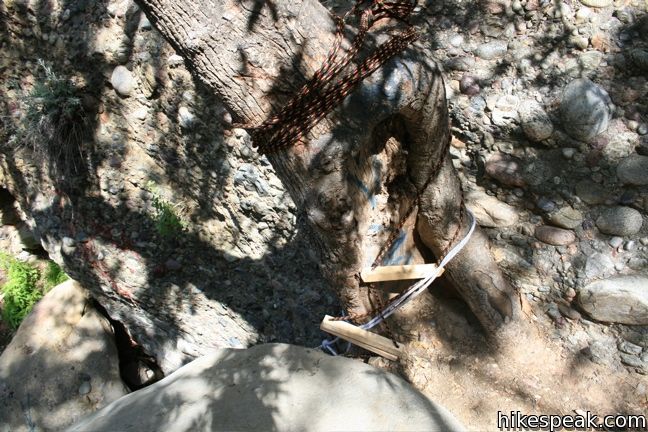
Most hikers turn around at the falls, but it is possible to continue up the canyon. A rope to the left of the falls may be used to climb above the waterfall and continue upstream. There is also a path a few hundred feet downstream, on the right as you face away from the falls, which can be used to climb out of the canyon and rejoin the creek above the falls. The trail (if you can still call it that) requires careful rock-hopping and log crossing to continue upstream through the narrow gorge. Make your way up to a short sloping cascade, the less impressive Upper Santa Ynez Falls, and climb to the left of the creek to a rope ladder that drops down from a crevice between a large boulder and the canyon wall. The short ladder takes a surprising amount of effort to climb, as the wooden steps swing underneath the rock, charging your upper body with the bulk of the lifting. Pull yourself out of the crevice and onto the boulder to keep charging upstream. Once above the ladder, the canyon widens again and the path fades. Most turn around here or follow a faint path to the left down a parallel canyon to rejoin the trail below, but this should be considered an off-trail adventure.
The most pleasant park of this hike is the shaded woodland leading up the Santa Ynez Falls. The common turnaround point at the waterfalls creates a very pleasant 2.5-mile hike. There is a good amount of poison oak along the trail, so long pants are recommended. Dogs are not allowed on this hike as it passes through Topanga State Park. No fee or permit is required, so get out and enjoy!
Directions to the Trailhead
- From PCH, take Sunset Boulevard inland for half a mile.
- Turn left onto Palisades Drive and head north for 2.4 miles.
- Turn left onto Vereda de la Montura, and park on either side of the street in the permitted areas.
- The trail begins on the right side of the street at the bottom of the hill (before the private neighborhood gates).
Trailhead Location
Trailhead address: 17399 Vereda De La Montura, Pacific Palisades, CA 90272
Trailhead coordinates: 34.0782, -118.56745 (34° 04′ 41.52″N 118° 34′ 02.81″W)
You may also view a regional map of surrounding Los Angeles trails and campgrounds.


 | Eagle Rock from Trippet Ranch This 4.5-mile loop takes Musch Trail and Eagle Springs Fire Road to visit an exceptional sandstone summit in Topanga State Park. |
 | Eagle Rock from Santa Ynez Canyon This 7.4-mile hike takes the long route from a canyon in the Pacific Palisades up to the panoramic sandstone summit. |
 | Temescal Peak This 5.8 to 7.6-mile hike ascends Temescal Ridge to a summit with sweeping views over Topanga State Park and the Santa Monica Mountains. |
 | Skull Rock This 1.5-mile hike descends Temescal Ridge to a head-shaped formation with great views over Santa Monica Bay. |
 | Parker Mesa Overlook This steep out-and-back hike rewards the effort with excellent views of the Pacific Ocean. |
 | Temescal Canyon This 2.6-mile loop offers a variety of scenery and decent exercise, despite its relative brevity. |
 | Sullivan Ridge A prominent lone-standing Live Oak along Sullivan Ridge makes a natural turnaround point and a 7.5 to 8.3 mile round trip hike. |
 | More trails in the Santa Monica Mountains Explore other destinations in the range. |
 | La Jolla Canyon Falls This 1.5-mile hike visits a short seasonal waterfall in Point Mugu State Park on the west end of the Santa Monica Mountains. |
 | Solstice Canyon This easy and level 2.6-mile out and back hike visits the ruins of a burned down ranch and a small waterfall. |
 | Sturtevant Falls This 3.3-mile hike visits a 60-foot waterfall and a lush cottage-lined canyon. |
 | More waterfalls around Los Angeles Explore other waterfalls in the Santa Monica and San Gabriel Mountains. |
Common Questions about Santa Ynez Falls in the Santa Monica Mountains
- Is the trail open?
- Yes. You should expect to find that Hike to Santa Ynez Falls is open. There are no recent reports of trail closures. If you discover that the trail is closed, please help your fellow hikers by reporting a closure.
- Is this trail free to access?
- Yes, Hike to Santa Ynez Falls is free to access. No entrance fee, pass, or permit is required. If you discover that access rules have changed, please provide feedback on your experience.
- How much time does this hike take?
- It takes approximately 1 hour 15 minutes to hike Hike to Santa Ynez Falls. Individual hiking times vary. Add extra time for breaks and taking in the views.
- How long is this hike?
- The hike to Hike to Santa Ynez Falls is a 2.5 mile out and back with 250 feet of elevation change.
- Are dogs allowed on this trail?
- No, dogs are likely not allowed on Hike to Santa Ynez Falls. The trail is primarily open to hikers.
- Will I see a waterfall on this hike?
- Yes, Hike to Santa Ynez Falls features a waterfall.
- What mountain range is this trail in?
- Hike to Santa Ynez Falls is located in the Santa Monica Mountains.
- Where is the trailhead located?
- The trailhead for Hike to Santa Ynez Falls is located in Pacific Palisades, CA.
Trailhead Address:
17399 Vereda De La Montura
Pacific Palisades, CA 90272
Trailhead Coordinates:
34.0782, -118.56745 - What are the driving directions to the start of the hike?
To get to the trailhead: From PCH, take Sunset Boulevard inland for half a mile. Turn left onto Palisades Drive and head north for 2.4 miles. Turn left onto Vereda de la Montura, and park on either side of the street in the permitted areas. The trail begins on the right side of the street at the bottom of the hill (before the private neighborhood gates).
View custom Google Maps directions from your current location.
- Are there other trails near Hike to Santa Ynez Falls?
- Yes, you can find other nearby hikes using the Hikespeak Hike Finder Map.

22 Comments on Santa Ynez Falls in the Santa Monica Mountains
What hikers are saying:
✨ Generated summary of user commentsThis trail offers a lush, shaded escape that feels vibrant after rainfall, though the path becomes rugged and unmaintained near the falls. Hikers should prepare for rock scrambling and dense patches of poison oak, especially as the trail narrows into overgrown sections. Paul warns that rocks can be slimy and slippery, and visitors should watch for rattlesnakes during warmer months.
This was a great hike for our somewhat experienced seven and ten year old daughters. Bring water shoes for sure — even in November when the stream was very low they got wet feet. There’s a lot of scrambling through rocks in the stream but otherwise the trail is quite level and easy. We had no hope of getting all the way to the falls, though — that “small obstacle” stopped us. I wish someone would put ropes back!
…thinking of hiking this trail. What danger, if any, should I watch out for since I’m going to be alone? Mountain lions, maybe?
Mountain lions possible but very rare in that area. More common are ticks in the winter and rattle snakes in the summer. Bobcats and coyotes in that area as well, but an attack is rare and very unlikely. The biggest danger is falling on a slippery rock. The rocks can be slimy on top and very slippery.
Are dogs permitted on the hike?
Unfortunately dogs are not allowed.
I just did the hike down to the falls and then back up to the eagle spring road junction on Saturday (Feb 2), and it was PERFECT. I’ve been down to the falls before at other times of year, and while I expected it to be wetter than before with all the recent rain, I was exactly wrong. There wasn’t much to the falls, but there was also less water to slip into, and the temperature was great. The plants are all very happy and verdant as well. I definitely recommend heading up now!
Can you get to the Santa Ynez Falls from Topanga state park on Reseda Blvd? It says there you can, but I haven’t been able to find it.
Hi Brittany,
It would be quite a hike to Santa Ynez Falls from Reseda Boulevard (over 13 miles round trip). From Reseda Blvd, you would hike up to Dirt Muholland and continue south up Temescal Ridge Fire Road for 1.9 miles to Hub Junction. Turn right and head west across Eagle Springs Fire Road. Hike 1.3 miles to Eagle Junction and continue for another 1.1 miles on Eagle Springs Fire Road to the top of Santa Ynez Canyon Trail. Turn left and hike 1.6 miles down to the waterfall trail junction. Turn left again and hike 0.6 miles up to Santa Ynez Falls. All junctions should be well marked.
Gotcha! Thanks for the tip!:) I was trying to find out how they all connected. I love long hikes so I’m gonna try this route.
This is not a great hike to do during the summer. I just went (August) – Theres no water in the creek (so no waterfall). The trail isn’t being maintained this time of year, and there’s a lot of poison oak.
is there any water now at this time in the year? is the trail recommended for the next few weeks in May?
I’ve just hiked this trail today. There is no water this time. The trail for the waterfall is unmaintained. We couldn’t get there. But it was really nice hiking, two beginners of my friends enjoyed it!
I attempted this trail yesterday (NOV 5,Tuesday) with a friend. I printed off the long description of exactly how to get there and how to get through to the waterfall, and after the big steep wall with the concrete ledges, we came across that “dense forest” that was unfortunately, impassable. My friend and I were trapped between two fences about 30-40 yards length, we were at the very top of a steep ledge with the concrete ledges over looking a “dense forest” going underneath what appeared to be a bridge/street. Underneath this bridge, I couldn’t see through the “dense forest” to the other side. We had no option but to turn around. We were very disappointed and we thought we had followed the directions perfectly, but we hit a huge obstacle and didn’t want to go trudging through the swamp of a forest that we were unfamiliar with. Is this trail maintained at a certain time of the year that is best? I would really love to see this waterfall and would love to climb it when it’s safest to do so. My friend and I both love to climb and do fun things and see beautiful parts of nature but we are not risking our lives, or any kind of injury, to do so. I am sure all hikers can understand. Please reply with any suggestions for this hike! Thank you all nature lovers and adventure seekers!!!!!
I went 2 weeks ago and was really upset because it was such a long hike and we got lost. We parked by the parking lot for $10 then went to the eagle rock trail then went back to the Santa ynez trail which is supposed to lead to the waterfall. It kept going down for like 2 miles then finally we see a sign pointing to either the waterfall or trippet. We took the waterfall side which is on the left and we then we see a sign that says “unmaintained area”. It looks like nobody ever goes through that because the trail is so narrow but we still went through because we really wanted to see the falls and it was hot so we wanted to see some water. We didn’t even see any signs of water anywhere and it looks like there was a river there somewhere but no water at all. As we continue that unmaintained trail, all we saw are bushes of poison oak but we still went through until there is no more trail. We still kept going and made our own trail but still no sign of water. All we saw was a forest. We finally decided to get back, disappointed.
Is the water safe/not contaminated for dogs and children to play in the grotto beneath the reservoir on the santa ynez trails just off palisades drive below the restaurant
is there any over night camping allowed?
Nearby Musch Camp is a hike-in campground with eight tent sites to backpackers with amenities like picnic tables, drinking water, and flush toilets. Sites may be reserved for $7 per night on a first-come first-serve basis. More information with this hike to Eagle Rock in Topanga State Park.
Has anyone done this hike lately? I assume it has water but is it passable?
I hiked the Santa Ynez waterfall today.
It is definitely passable. Just a few rocks to cross the stream but nothing hard. The waterfall wasn’t as impressive as I thought but the hike is very pleasant, shady and very green after the rainy days we had. It you can wear real hiking shoes would be better than regular sneakers. The rocks could be slippery and if you are adventurous enough, you could climb with the help of the rope attached at the rock by the waterfall and go above.
Some people did climb the waterfall and came down afterwards and some people tried but their shoes were slipping from the sleepery rock.
Hope you are going to enjoy it as much as I did today.
It’s a very short hike for my standards but really nice and green as I said.
Perfect for those hot summer days.
Horrible trail. Doesn’t look like the photos and it’s covered in Poison Oak. Dangerous and not that fun. There wasn’t any water, not even at the “waterfall”.
Has anyone been on a hike there since the rain passed though about a month or so ago and knows if the fall is going? I’ve been to other trails in the area awhile ago but wanted to find a new place.
Hiked it on July 14, 2019. The stream isn’t moving quickly but there is quite a bit of water and the waterfall is still going. Remember this year we’ve had an absolute ton of rain so in future years I wouldn’t expect any water in July. We took our 4yo kids and they were able to hang, but were seriously wiped at the end. The needed quite a bit of help, especially toward the waterfall which requires some rock scrambling and I found it quite challenging as well. I did hear some rattles on the way in but never saw any snakes. And the trail past the half mile point can be hard to navigate and very overgrown.