Palouse Falls State Park Waterfall Trail Campground Viewpoint Washington
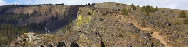
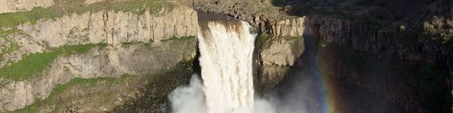
Palouse Falls appears like magic. The drive into Palouse Falls State Park crosses a broad grassy plain where you would never expect to find a waterfall. At the end of the dusty road, the land opens up to reveal a beautiful scene. A 180-foot waterfall plunges from the basalt wall of a gouged-out canyon. A short, 0.15-mile round trip walk explores a clifftop viewpoint with great... Read more.
OK! Add to trails I’ve hiked
OK! Add to trails I want to hike
Tagged with · LaCrosse · Palouse Falls State Park · Washington State Parks · Waterfalls
Distance: 0.15 miles · Elevation change: 40 feet
By: Published: Last updated: June 5, 2018
Catherine Creek Arch Columbia River Gorge National Scenic Area Hike Washington
Catherine Creek Arch is a surprising creation - a bridge-like span of rock along a ledge of basalt. A 1-mile round trip hike leads to the foot of Catherine Creek Arch (and longer loops in the area are also possible). This short and sweet outing entertains hikers of all ages. Part of the Columbia River Gorge National Scenic Area, Catherine Creek is located on the Washington side of the west... Read more.
OK! Add to trails I’ve hiked
OK! Add to trails I want to hike
Tagged with · Arches · Columbia River Gorge National Scenic Area · Free Trails · Lyle
Distance: 1 mile · Elevation change: 100 feet
By: Published: Last updated: May 9, 2018
Catherine Creek Trail Columbia River Gorge National Scenic Area Wildflower Loop Hike Washington
Hikers pack the slopes of Dog Mountain to see spring wildflowers, but tackling a lot of elevation is not required to see one of the best blooms in Columbia River Gorge National Scenic Area. Instead, visit Catherine Creek, where an easy, paved 0.9-mile loop (with just 100 feet of elevation change) floods with wildflowers in the spring and early summer. Catherine Creek Interpretive Trail... Read more.
OK! Add to trails I’ve hiked
OK! Add to trails I want to hike
Tagged with · Columbia River Gorge National Scenic Area · Free Trails · Lyle · Nature Trails · Wildflowers
Distance: 0.9 miles · Elevation change: 100 feet
By: Published: Last updated: May 9, 2018
Pothole Falls Round Lake Loop Lacamas Potholes Lacamas Lake Regional Park Camas Washington Hike
Potholes aren't always bad. The creatively carved-out bedrock at Pothole Falls adds to the allure of the cascades. Pothole Falls is just a stone's throw from Round Lake, a 26-acre body in Lacamas Lake Regional Park in Camas, Washington. Round Lake Loop Trail offers a relaxing nature trail through lake-edge forest. Circle Round Lake and check out Pothole Falls on a 1.6-mile outing with 200... Read more.
OK! Add to trails I’ve hiked
OK! Add to trails I want to hike
Tagged with · Camas · Free Trails · Lacamas Lake Regional Park · Lakes · Nature Trails · Waterfalls
Distance: 1.6 miles · Elevation change: 200 feet
By: Published: Last updated: November 7, 2018
Dog Mountain Trail Columbia River Gorge National Scenic Area Dog Mountain Loop Hike Washington
It isn't pack mentality that makes Dog Mountain one of the most popular hikes on the Washington side of the Columbia River Gorge. The grassy slopes near the summit put on a winning display of spring wildflowers, enhancing year-round views over the gorge's beautiful surroundings. Dog Mountain Trail is steep and largely forested, ascending 2,825 feet in 3 1/3 miles. Two viewpoints along the... Read more.
OK! Add to trails I’ve hiked
OK! Add to trails I want to hike
Tagged with · Cascade Range · Columbia River Gorge National Scenic Area · Free Trails · Stevenson · Summits
Distance: 7.4 miles · Elevation change: 2825 feet
By: Published: Last updated: September 9, 2019
Coyote Wall Hike Columbia River Gorge National Scenic Area Little Maui Trail Little Moab Trail Coyote Wall Trail Washington
Take a drive through the Columbia River Gorge and you're sure to be impressed by a diagonal band of cliffs on the Washington side of the gorge that rise from the river toward the mountains above. These grand and daunting cliffs are called Coyote Wall or the Syncline. A network of single-track trails and old jeep roads extend up alongside the columnar basalt ledge. Coyote Wall is quite... Read more.
OK! Add to trails I’ve hiked
OK! Add to trails I want to hike
Tagged with · Cascade Range · Columbia River Gorge National Scenic Area · Free Trails · White Salmon
Distance: 5.8 miles · Elevation change: 1575 feet
By: Published: Last updated: August 31, 2019
Camping in Beacon Rock State Park Main Campground Columbia River Gorge Washington
Tucked into the Washington side of the Columbia River Gorge, Beacon Rock State Park has great places camp and kick back after a day of traveling in the gorge or hiking Hamilton Mountain and Beacon Rock. Main Campground In the forest up the road from Hamilton Mountain Trailhead, you'll find the park's main campground spread around a single loop. A mossy ledge of basalt rises over one side... Read more.
By: Published: Last updated: June 24, 2018
Hamilton Mountain Trail Beacon Rock State Park Hike Washington Columbia River Gorge Pool of the Winds Rodney Falls Hike Hamilton Mountain Loop
Only hike Hamilton Mountain Trail if you like charming forests, bold waterfalls, and awesome cliff-top views. Hamilton Mountain Trail passes a viewpoint for the Pool of the Winds, where Rodney Falls plunges into a rock-wrapped punchbowl. The trail rises to a summit along the Columbia River Gorge, ascending 2,025 feet on a 7.75-mile lollipop loop. Some of Hamilton Mountain's best views... Read more.
OK! Add to trails I’ve hiked
OK! Add to trails I want to hike
Tagged with · Beacon Rock State Park · Cascade Range · Stevenson · Summits · Washington State Parks · Waterfalls
Distance: 7.75 miles · Elevation change: 2025 feet
By: Published: Last updated: August 29, 2019
Beacon Rock Trail Beacon Rock State Park Hike Washington Columbia River Gorge
Beacon Rock rises like a stone tower with sheer cliffs dropping to the Columbia River. Beacon Rock Trail could be the Columbia River Gorge relative of Moro Rock Trail in Sequoia National Park. The trail is built right up the side of the basalt monolith, using over fifty switchbacks and at least a dozen cliff-straddling bridges to reach a pointed summit. The hike up Beacon Rock Trail is 1.6... Read more.
OK! Add to trails I’ve hiked
OK! Add to trails I want to hike
Tagged with · Beacon Rock State Park · Cascade Range · Stevenson · Summits · Washington State Parks
Distance: 1.6 miles · Elevation change: 600 feet
By: Published: Last updated: November 7, 2018
Guler Ice Cave hike Washington Gifford Pinchot National Forest
The Cascade Range is home to many caves including volcanic lava tubes and glacier ice caves. The Guler Ice Cave south of Mount Adams offers a sample of both. Through the early summer this cave contains impressive ice features like frozen stalactites and stalagmites. You will see the most ice if you visit in April and May. As the season warms the cave loses its ice, but remains fun to... Read more.
OK! Add to trails I’ve hiked
OK! Add to trails I want to hike
Tagged with · Cascade Range · Caves · Gifford Pinchot National Forest · Lava Tubes
Distance: 0.25 miles · Elevation change: 25 feet
By: Published: Last updated: January 1, 2019