Cascade Mountain and Porter Mountain in the Adirondack Mountains
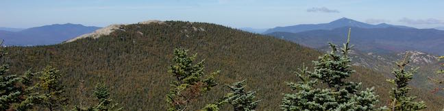
Southeast of Lake Placid, you'll find a popular hike to a pair of scenic summits. Cascade Mountain (4,098 feet) and Porter Mountain (4,059 feet) are the thirty-sixth and thirty-eighth tallest peaks in the Adirondack Mountains and are members of the 46 Adirondack High Peaks. Cascade and Porter are two of the easiest High Peaks to reach, thanks to maintained trails and a relatively manageable hike length (that still delivers a workout). ...Read more.
Distance: 6.2 miles · Elevation change: 1925 feet
By: Published: October 18, 2016 Last updated: December 5, 2025
Ravine Trail, Vernal Pool Trail, and Oak Trail in Binghamton University Nature Preserve
The smart people who shaped Binghamton University knew that deep-rooted oaks can teach us more than ivory towers. With the good foresight, the SUNY Binghamton campus set aside 182 acres of wetlands and woodlands for the benefit of students, faculty, and the community. On a first visit to Binghamton University Nature Preserve, Pond Trail and Marsh Trail are recommended routes for appreciating the heart of the preserve. ...Read more.
Distance: 1.15 miles · Elevation change: 200 feet
By: Published: July 30, 2015 Last updated: April 8, 2026
Pond Trail and Marsh Trail in Binghamton University Nature Preserve
Some centers of higher learning probably overlook nature's value in education, but not Binghamton University. This SUNY Institution in Vestal, New York set aside 182 acres for the benefit of students, faculty, and the community. Several intersecting trails explore Binghamton University Nature Preserve, creating numerous hiking options, like this one — a figure-eight loop on the easiest and most scenic trails around the wetlands in the middle of the preserve. ...Read more.
Distance: 2.6 miles · Elevation change: 90 feet
By: Published: July 30, 2015 Last updated: April 8, 2026
Forest Loop Trail in Binghamton University Nature Preserve
We can learn a lot from nature, which is probably why Binghamton University, a SUNY Institution in Vestal, New York had the foresight to preserve a 182-acre natural space right on its campus. Binghamton University Nature Preserve has hillsides and valleys full of forests and marshes with lots of interconnected trails open to the students and the public. ...Read more.
Distance: 1.15 miles · Elevation change: 255 feet
By: Published: July 30, 2015 Last updated: December 5, 2025
High Line Trail in New York City
On the lower west side of Manhattan, an old raised rail line that was headed for demolition has been transformed into an attractive asset, a surprising park that hovers above city streets. The High Line has become a New York City landmark, offering a one-of-a-kind walk with a refreshing perspective of NYC. Like the rest of New York City, the High Line Trail has something for everyone, whether you need a bit of nature, crave art, enjoy bird watching or people watching. ...Read more.
Distance: 3 miles · Elevation change: 40 feet
By: Published: June 30, 2015 Last updated: December 5, 2025
Cliff Trail – Long Trail – Mildred Faust Trail Loop in Clark Reservation State Park
The New York State Park website describes Clark Reservation as 'a geologic wonder of the last ice age and a botanist's paradise.' It's all that and just 5 miles from Syracuse! The star of the park is Glacier Lake, a glacial plunge pool lake surrounded by dramatic limestone cliffs. Over a dozen trails explore this 365-acre park, allowing visitors to put together several different hikes. ...Read more.
Distance: 1.95 miles · Elevation change: 150 feet
By: Published: January 6, 2014 Last updated: April 10, 2026
North County National Scenic Trail to the Hang Glider Launch Site in Labrador Hollow Unique Area
For a soaring view over Labrador Hollow Unique Area, a state forest in Central New York, take a hike up Jones Hill to a scenic overlook at a Hang Glider Launch Site. There are two overlapping routes to the launch site from the trailhead for Tinker Falls Trail (a short hike to a lovely waterfall). Onondaga Sky Line Trail is a wide dirt road offering a 1. ...Read more.
Distance: 2.5 miles · Elevation change: 650 feet
By: Published: January 4, 2014 Last updated: April 8, 2026
Tinker Falls in Labrador Hollow Unique Area
Tinker Falls is a beautiful 50-foot waterfall in Labrador Hollow Unique Area, a New York State Department of Environmental Conservation (NYSDEC) State Forest on the border of Onondaga County and Cortland County in Central New York. The base of the waterfall can be reached via Tinker Falls Trail on an easy half-mile round trip hike with 50 feet of elevation gain. ...Read more.
Distance: 0.5 miles · Elevation change: 50 feet
By: Published: January 3, 2014 Last updated: April 6, 2026
Labrador Hollow Boardwalk in Labrador Hollow Unique Area
Tranquil Labrador Pond lies at the heart of New York State's Labrador Hollow Unique Area on the border of Onondaga County and Cortland County. Fine views of Labrador Pond can be found on Labrador Hollow Boardwalk, a half-mile long wheelchair-friendly walkway through the wetlands bordering Labrador Pond. The quick walk reaches a viewpoint on the shore of the hill-cradled pond and is a great introduction to the Labrador Hollow Unique Area. ...Read more.
Distance: 0.5 miles · Elevation change: 10 feet
By: Published: January 3, 2014 Last updated: December 5, 2025
Southern Exposure Snowshoe Trail at Beaver Lake Nature Center
When the snow falls in Central New York, it's time to trade in your hiking books for snowshoes and explore a wonderland of winter landscapes. Onondaga County's Beaver Lake Nature Center is a perfect destination for winter fun. The 660-acre park operates trails for snowshoeing and cross-country skiing, and even rents snowshoes for a small fee so that everyone can get in on the fun. ...Read more.
Distance: 2.2 miles · Elevation change: 50 feet
By: Published: December 31, 2013 Last updated: April 10, 2026