Tenaja Falls in the Santa Ana Mountains
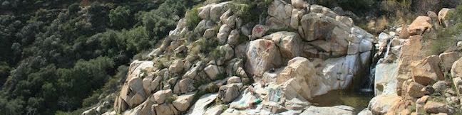
Tenaja Falls pours over a polished rock staircase in the San Mateo Canyon Wilderness of the Santa Ana Mountains. Even through the waterfall's setting is picturesque and remote, the hike to the waterfall is a short and easy, following Tenaja Falls Trail for 1.5 miles round trip with 275 feet of elevation change. Tenaja Falls totals 150 feet in height with multiple tiers. ...Read more.
Distance: 1.5 miles · Elevation change: 275 feet
By: Published: January 15, 2018 Last updated: February 15, 2026
Heaps Peak Arboretum in the San Bernardino Mountains
Get to know the plants, animals, and natural history of Southern California at Heaps Peak Arboretum. Located near Lake Arrowhead, the arboretum is a developed piece of San Bernardino National Forest. Sequoia Trail is the main trail through Heaps Peak Arboretum, covering 3/4 of a mile with 90 feet of elevation change. The star of the trail is a planted grove of sequoiadendron giganteum, or what us non-Latin speakers call giant sequoias. ...Read more.
Distance: 0.75 miles · Elevation change: 90 feet
By: Published: December 23, 2016 Last updated: December 5, 2025
Kwaay Paay Peak Trail in Mission Trails Regional Park
Pay a visit to Kwaay Paay Peak for an efficient workout that's rewarded with panoramic views. The 2.5-mile round trip hike to the 1,194-foot summit climbs 885 feet, with steep stretches that will have your heart pumping. The summit is just ten miles from downtown San Diego, within the 6,800 acres of Mission Trails Regional Park, so you'll see beautiful natural landscapes and cityscapes on this fun San Diego hike. ...Read more.
Distance: 2.5 miles · Elevation change: 890 feet
By: Published: March 30, 2015 Last updated: December 5, 2025
Monserate Mountain in Fallbrook
Monserate Mountain offers a workout of a hike, beginning just off Interstate 15 in the Northern San Diego County city of Fallbrook, just ten miles south of Temecula in Riverside County. There is 1,200 vertical feet between the trailhead at the base of Monserate Mountain and the panoramic summit at the top, tackled on a 1 2/3-mile ascent. You can turn around at the top for a 3 1/3-mile out-and-back hike or explore more of Monserate Mountain Preserve on a 4. ...Read more.
Distance: 4.4 miles · Elevation change: 1200 feet
By: Published: February 11, 2014 Last updated: December 5, 2025
Canyon View Loop Trail in Whitewater Preserve
You would not expect to find a Whitewater River in the vicinity of Palm Springs, but this surprising river is vital for the fertility of the Coachella Valley, bringing wonderful water from the San Bernardino Mountains to the desert below where it empties into the Salton Sea. Journeyman hikers can pass through Whitewater Preserve on the Pacific Crest Trail and day hikers can get in on the action too. ...Read more.
Distance: 3.75 miles · Elevation change: 650 feet
By: Published: December 19, 2013 Last updated: April 8, 2026
Weir Canyon Trail in Weir Canyon Wilderness Park in Santiago Oaks Regional Park
Where can you go for a loop hike in a wilderness area in Orange County? Why, Weir Canyon of course. Weir Canyon Trail provides a 3.8-mile loop over undulating terrain on the side of Weir Canyon in the Anaheim Hills below the Santa Ana Mountains. There is 350 feet of elevation between the high and low points of the loop, but all the ups and downs along the trail make it feel more like a hike with a thousand feet of elevation gain. ...Read more.
Distance: 3.8 miles · Elevation change: 350 feet
By: Published: November 4, 2013 Last updated: April 9, 2026
West Bluff Trail Loop in Upper Newport Bay Nature Preserve
Newport Bay is a vital stopover for birds migrating across Southern California. Hikers can explore the estuary too, on trails in Upper Newport Bay Nature Preserve, a 142-acre coastal habitat managed by the Orange County Parks Department. The preserve's West Bluff has a few trails (some open to equestrians and bikers) that provide easy hikes of a mile or more, including the 2. ...Read more.
Distance: 2.5 miles · Elevation change: 75 feet
By: Published: September 26, 2013 Last updated: December 5, 2025
El Cariso Campground in the Santa Ana Mountains
El Cariso Campground is a 24-site campground in the Santa Ana Mountains near the intersection of Ortega Highway (Route 74) and Main Divide Road on the border between Orange County and Riverside County. At 2,600 feet above sea level, the campground straddles a scenic mountain pass and can be reached easily from Lake Elsinore to the east or San Juan Capistrano to the west. ...Read more.
By: Published: August 2, 2013 Last updated: April 9, 2026
El Cariso Nature Trail in the Santa Ana Mountains
El Cariso Nature Trail is a self-guided hike in the Santa Ana Mountains, beautifully situated on the range's main divide straddling the border of Orange and Riverside counties. The 1.35-mile loop is lined with small panels that identify and describe the area's plants. Starting just off Ortega Highway, at 2,600 feet above sea level, the short loop presents excellent views across the range. ...Read more.
Distance: 1.35 miles · Elevation change: 125 feet
By: Published: August 2, 2013 Last updated: December 5, 2025
San Jacinto Peak via Marion Mountain Trail in the San Jacinto Mountains
San Jacinto Peak is one of the true crowns of Southern California and is a crowning achievement for any hiker who reaches the summit. San Jacinto Peak is the second highest mountain in Southern California and the pinnacle of the San Jacinto Mountain Range at 10,834 feet above sea level. Hikers who spar with San Jacinto Peak should be prepared for an all day challenge. ...Read more.
By: Published: July 8, 2013 Last updated: April 10, 2026