High View Nature Trail in Joshua Tree National Park
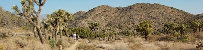
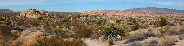
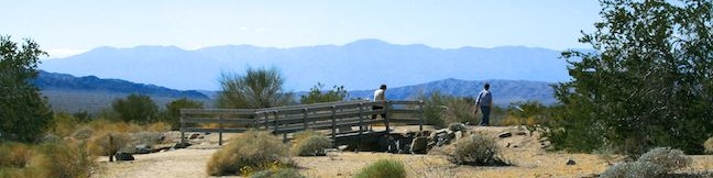
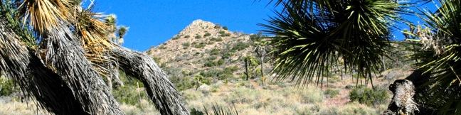
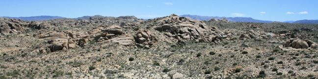
While many national park nature trails are short, level, and informative, High View Nature Trail offers a bit more for hikers, 325 feet of elevation gain on a 1 1/3-mile loop. The trail ascends a desert ridge with views over Yucca Valley and toward Southern California's tallest peak, San Gorgonio Mountain, in the mountains to the west. The loop starts near Black Rock Campground on the west side of Joshua Tree National Park, making it one of the easiest trails to reach for travelers coming from Los Angeles. ...Read more.
Distance: 1.35 miles · Elevation change: 325 feet
By: Published: October 1, 2014 Last updated: December 6, 2025
Crown Prince Lookout in Joshua Tree National Park
Joshua Tree National Park has a lot of interesting history, like old gold mines and Native America sites. Crown Prince Lookout highlights another period of the park's history, when a warning station for World War II airplanes was located atop a granite formation near today's overlook. The lookout and a second nearby viewpoint can be reached via an easy 3. ...Read more.
Tagged with · National Parks · Off Trail
Distance: 3.25 miles · Elevation change: 50 feet
By: Published: February 21, 2013 Last updated: December 5, 2025
Ryan Ranch in Joshua Tree National Park
Despite the harshness of the desert environment, some people actually made a home in what is now Joshua Tree National Park. Miners, Jepp and Tom Ryan built a large house next to Ryan Mountain in 1898. Over a hundred years later, much of their old adobe structure still stands and can be easily visited today. Two routes lead to the ruins of Ryan Ranch. ...Read more.
Tagged with · National Parks · Ruins
Distance: 1.2 miles · Elevation change: 85 feet
By: Published: February 20, 2013 Last updated: December 7, 2025
Bajada Trail in Joshua Tree National Park
Bajada All-Access Nature Trail is located on the southeast side of Joshua Tree National Park between the 10 Freeway and the Cottonwood Visitor Center. The hike, which you could do in flip-flops or tennis shoes, is a 0.3-mile loop with about 5 feet of elevation change. If that wears you out, there are three benches along the way where you can pause to admire the vegetation and scenery. ...Read more.
Tagged with · National Parks · Nature Trails
Distance: 0.3 miles · Elevation change: 5 feet
By: Published: February 19, 2013 Last updated: December 5, 2025
Wonderland Wash in Joshua Tree National Park
In between Barker Dam Trail and Wall Street Mill Trail is Wonderland Wash Trail, an unmaintained single track through the Wonderland of Rocks in Joshua Tree National Park. This less-traveled trail passes monzogranite mounds that are a popular playground for rock climbers and bouldering enthusiasts. There is no defined end to the trail, but a hike to the prominent rock formation known as the Astro Dome creates a rewarding 2. ...Read more.
Tagged with · Bouldering · National Parks
Distance: 2.1 miles · Elevation change: 75 feet
By: Published: December 20, 2010 Last updated: April 8, 2026
Wall Street Mill in Joshua Tree National Park
For the first half of the 20th century, the desert land now known as Joshua Tree National Park was scattered with miners on the hunt for gold and silver. When ore was mined, it was sent to a mill to be crushed and have the precious metal extracted. The ore from Desert Queen Mine and other mining operations passed through Wall Street Mill, which is located in Queen Valley near the Wonderland of Rocks. ...Read more.
Tagged with · National Parks · Ruins
Distance: 2.15 miles · Elevation change: 115 feet
By: Published: December 14, 2010 Last updated: April 13, 2026
Contact Mine in Joshua Tree National Park
Contact Mine was in operation at the start of the 20th century, extracting gold and silver from the mountains south of Twentynine Palms, California. A hundred years of desert decay have left the mine rusty but recognizable. The old road to the mine is worn down and eroded, now just a little-used hiking trail. This 3.95-mile round trip trek ascends 700 feet up a wash, a canyon, and an old road to a mountainside mine site that offers a glimpse into the mining history of Joshua Tree National Park. ...Read more.
Distance: 3.95 miles · Elevation change: 700 feet
By: Published: December 9, 2010 Last updated: April 9, 2026
Arch Rock in Joshua Tree National Park
Want to see a natural arch in Joshua Tree National Park? Take a short hike to Arch Rock within the granite formations surrounding White Tank Campground. An easy and enjoyable 0.3-mile loop leaving the campground is a must-do stroll for anyone staying at White Tank Campground. Other park visitors can now enjoy a 1.3-mile lollipop loop hike that begins from a trailhead along Pinto Basin Road. ...Read more.
Tagged with · Arches · National Parks · Nature Trails
Distance: 1.3 miles · Elevation change: 100 feet
By: Published: December 3, 2010 Last updated: April 10, 2026
Warren Peak in Joshua Tree National Park
Warren Peak is a high point on the western edge of the Little San Bernardino Mountains in Joshua Tree National Park. Located away from Park Boulevard, Warren Peak offers private peace of mind and near endless views. A 5.5-mile round trip hike to the 5,103-foot summit begins from Black Rock Campground, the only campground in the park where visitors can sleep surrounded by Joshua trees. ...Read more.
Tagged with · National Parks · Summits
Distance: 5.5 miles · Elevation change: 1000 feet
By: Published: May 14, 2010 Last updated: December 5, 2025
Lucky Boy Vista in Joshua Tree National Park
Lucky Boy Vista Trail offers a level 2.5-mile round trip hike to a modest overlook at the site of an old mine. The trailhead is a half-mile from the Pine City - Desert Queen Mine Trailhead and easy to find. There are no junctions along the trail to be concerned with. From the parking area, hike southeast across the desert on an easy track that climbs just 125 feet over 1. ...Read more.
Tagged with · National Parks
Distance: 2.5 miles · Elevation change: 125 feet
By: Published: May 13, 2010 Last updated: December 5, 2025